Remote Sensing for Mineral Exploration
BACK TO PROJECTS
Name of associated firm :
-
Project Location within Country:
Classified
Start Date:
July 1996
Completion Date:
August 1996
Project Description
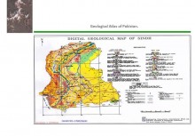
Preparation of geological maps developed from Landsat TM imageries. The project includes development of geological hard copy maps. Sendo colour maps for interpretation purpose produced by running different filters. The project also includes radiometric and geometric correction of the raw data acquired from SUPARCO.
Services
-
Preparation of geological map from Landsat TM digital data
-
Geometric and radiometric corrections on image production of sendo colour map for exploration purpose