Jinnah Naval Base, AM/FM-GIS
BACK TO PROJECTS
Name of associated firm :
-
Project Location within Country:
Classified
Start Date:
January 1996
Completion Date:
March 1997
Project Description
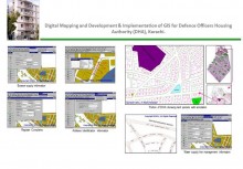
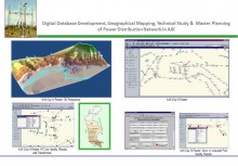
A Digital Terrain Model (DTM) of the seabed of the JNB project area is being developed. For this purpose the spot-level/sounding data is provided by the Client, the data is provided on a regular basis so that the dredging work can be monitored through DTM computation and computer models.
Survey map of the housing scheme of JNB is prepared at 1:1K, 5K and 10K of different areas as spelled out in the TOR and these maps shall be digitized to produce Digital Base Map (DBM) for both Cadastre and feature data.
An overall base map of parcels and right of way has been digitally created, which is to be overlaid on the terrain model, to provide a base for all the development on top of it. Digital layers on DXF or ARC formats are created and services projected on the base map.
The services include telephone lines and poles, water line and valves, gas line, valves and cathode protection, electric distribution line, poles, and transformers, sewerage line and main-holes with invert levels, solid waste disposal area and capacity, storm water drains.
The database attributes like capacity, sizes profile and service data on geographical location, material of construction, maintenance schedule, travel impedances and other such technical specification shall be related and relational database of all the services will be created to do Structured Query Language (SQL) command operations.
A customized system will be developed and integrated with the map features to create fully functional AM/FM GIS for JNB.
Services
-
GPS survey to produce DTM at scale 1:1K, 1:5K and 1:10K
-
Complete data automation service and creation of automated mapping and facility management
-
Testing and training